
Voor het rapport “GIS and BIM integration: A High Level Global Report” is Henk als thought leader door Geospatial World geïnterviewd over het onderwerp. Lees hieronder het interview, het hele rapport is hier te vinden.

Integrated GIS and BIM Solutions for GeoDesign to GEOBIM Digital Transformation: A thought leaders interview
Prof. Henk Scholten
Spatial Informatics - Vrije Universiteit Amsterdam, Director Innovation at Geodan
“The government has to play a role in providing a mandate wherein BIM along with Geo, would encourage the adoption of GIS and BIM technologies together in the infrastructure projects”
With over 42 years of research & academia experience, Prof. Henk Scholten is a leading scientist and founder of Geodan - a location intelligence company based in the Netherlands. In his interview with Geospatial World, Prof. Henk Scholten emphasized the role of a holistic data-driven collaborative approach to achieve sustainable development in the infrastructure industry. “We need to put all the effort together in coming up with solutions,” said Prof. Henk. Citing the example of the surge in traffic in the bridges of the Netherlands, Prof. Henk explained the role of integration of GIS and BIM in connecting workflows and processes and to tackle the siloed approach. “The bridges in the Netherlands and also in many other places are often congested with traffic– the design and maintenance of the bridges are being taken care of by different offices, instead of the office responsible for mobility.” Such offices functioning in silos often face challenges in mapping the asset data required for their engineering and modeling work. Such projects require data-driven project management solutions such as integrated GIS and BIM solutions. Integrated technology solutions help to connect these offices and integrate their workflow and data efficiently bringing in efficiency and improving productivity.

Need for integrated solutions: Transition from GeoDesign to GEOBIM
GeoDesign is a design framework to support technology professionals to leverage GIS across the infrastructure lifecycle of the industry. “Today, GeoDesign can be considered across the lifecycle of GEOBIM solutions,” said Prof. Henk. As per Prof. Henk, the role of GeoDesign is crucial during the pre-construction phase, which helps provide accurate project information for the next phase.
“I think, Geo-design is a part of the whole cycle of Geo-BIM, and there is freedom in the first phase to come up with all the ideas and plans for future development”
he added. However, he believes some stakeholders are only interested in the planning & design capabilities of integrated solutions like GIS and BIM and are not as keen on applying the integrated solution in the O&M phase. The limitation of integrated GIS and BIM to specific project lifecycle phases results in different workflows, and Prof. Henk considers this as the primary difference between GEOBIM and Geo-design. He concluded that BIM performs a vital role across the project lifecycle; however, an integrated GIS and BIM solutions will play an equally important role.
National Digital Twin Strategy and GEOBIM standards
The Netherlands has developed a National Digital Twin Strategy with a significant budget allocated for the purpose. The significant increase in the Field labs over the years has helped evolve the Digital Twin capabilities in the country.
“Field labs are the practical exercises that will be part of the solution at the end and are much required”
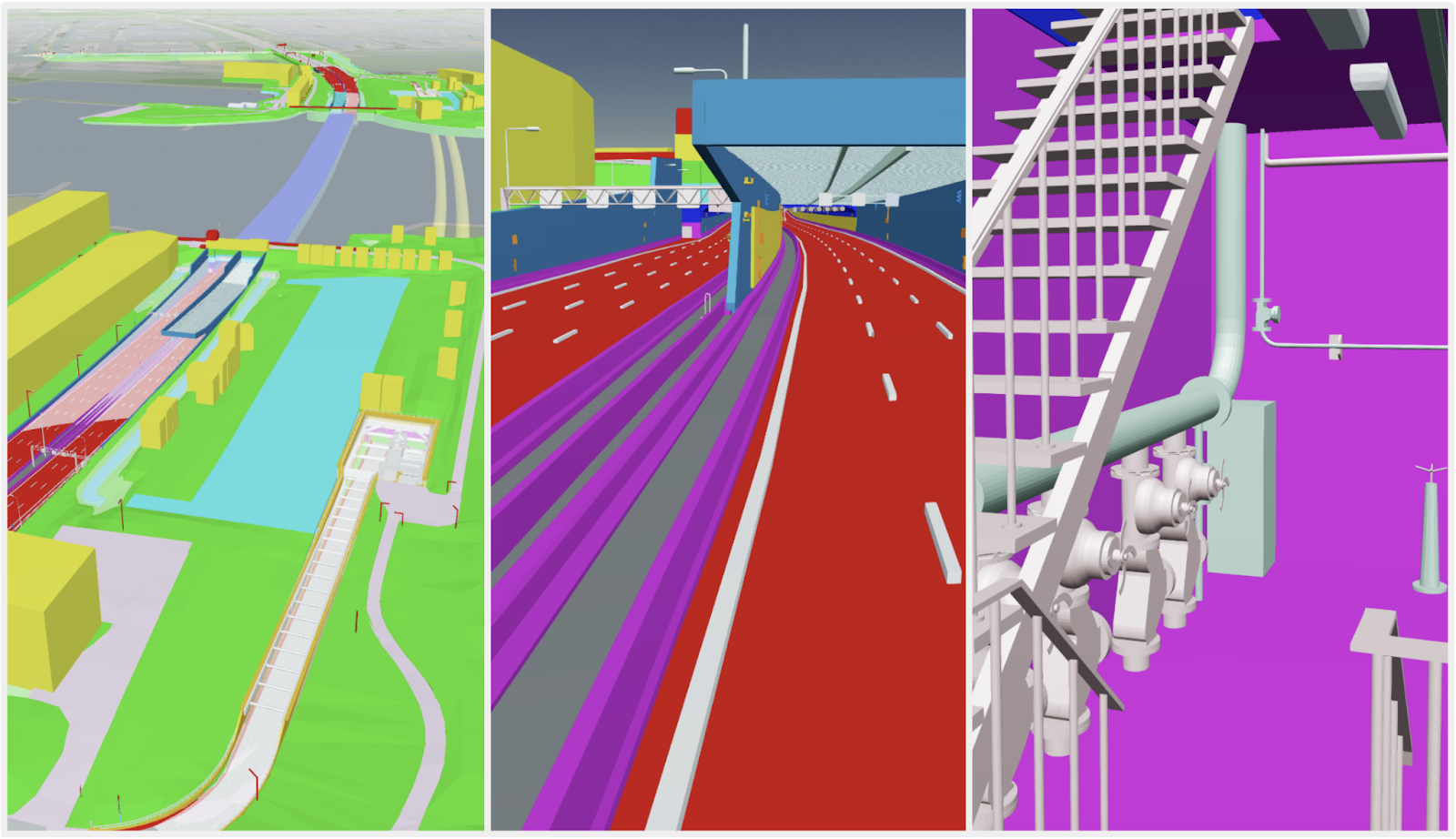
added Prof. Henk. For instance, there is a scope in the Ministry of Transport, Public Works and Water Management of Netherlands, also responsible for traffic management to undertake practical solutions utilizing the Digital Twin system. There is an existing opportunity to develop a digital twin for the southern tunnel of Rotterdam using a BIM model and further to integrate it with the digital twin of the Netherlands.
“Applications on real-world projects, i.e., the Field Labs are thus, required for expanded approach and evaluation of the true value of Digital Twin capabilities”
adds Prof. Henk.
Another important aspect of digital twins’ development is the understanding and recognition of the value of GEOBIM standards associated with them. Standards are critical for the development of digital twins, and according to Prof. Henk, there is a need for a more significant awareness among the stakeholders involved in the process. Citing the example of water barriers and dikes in the Netherlands, he comments, “It’s unbelievable that many stakeholders still don’t understand the value of geospatial infrastructure, and the standards associated with it. There is a need to change the contracts and include standards as necessary, otherwise, we cannot make the necessary progress. At present, the whole Netherlands is under a ‘Geo’ perspective in a digital twin, and as per the OGC standards, we now need to get to GEOBIM standards and processes,” he added.
Importance of integrated GIS and BIM for subsurface infrastructure
Present-day infrastructure asset project information and data serve as historical data for future engineers and asset managers. Hence, the preservation of built-asset data is critical for the expansion, maintenance, and repair of infrastructure.
“When we talk about a bridge, a hundred years ago, the estimations that a civil engineer might have made and used back then, may not be enough for the structure to be able to bear the traffic load that travels on that bridge today”
said Prof. Henk. The integration of traffic models within the BIM environment is a good start towards developing advanced Digital Twin systems. Such integrated technology solutions are crucial for the long-term resilience of sub-surface infrastructure. For instance, an integrated GIS and BIM platform helps visualize the location data alongside structural data. This enables asset managers to monitor infrastructure operations and develop predictive maintenance systems. “It’s clear that we need to make sure to know how strong the subsurface is. In 2021, we received the best Governmental Solution Award for subsurface that we developed for BRO – the Dutch Key Register of the Subsurface, wherein we integrated the ‘Geo’ aspect with the ‘BIM’ aspect.” he added. The BRO mandated subsurface data to be assessed in a GEOBIM model before the commencement of building projects. “And of course, looking means you must use it. This is one of the most wonderful examples of the integration of BIM and Geo” concluded Prof. Henk.
Advancement of integrated GIS and BIM: Government and academia
“The government has to play a role in providing a mandate wherein BIM along with Geo, would encourage the adoption of GIS and BIM technologies together in the infrastructure projects” said Prof. Henk. He added that the government needs to initiate a cloud environment for BIM models, which can help organize and provide access to built-asset information. From an academic point of view, Prof. Henk considers renowned institutions like TU Delft and TU Eindhoven at the forefront of the research and application of BIM solutions. “They are willing to integrate their solutions into a large environment, using digital twins,” he said. However, the components of GEOBIM focused on mobility, accessibility, and the energy transition are yet to take importance, he was quick to add. Prof. Henk believes the present focus of integrating GIS and BIM solutions for large-scale construction, environmental issues, mobility, traffic, and transportation will gradually shift in a positive direction in the next few years to come.